
Engineering work to date
Where this comes from. This page summarises two sets of engineering documents written in 2018, for other people: Associated Engineering's valuation of the plant and reservoir, prepared for Fish Creek Ranch, and MPE Engineering's North Distribution Assessment, prepared for the M.D. of Foothills. The co-op commissioned neither and has not had either re-checked. Every figure below is footnoted to the document it came from, and the MPE reports are published in full by West Foothills Water if you would rather read the originals. None of this is a commitment to a route, a cost, a water rate or a date.
The question members ask most often is whether anybody has actually engineered this, or whether it is an idea. It has been engineered, twice, and by two different firms. What has never happened is the funding and the decision to build.
The record, in order
Table 1 is the record in order, from the first hydrology study to the valuation.
| When | What |
|---|---|
| June 1998 | UMA Engineering Ltd. completes a hydrology study of Fish Creek and the maximum annual volume available for diversion at the proposed location [1]. |
| August 1998 | Alberta Environmental Protection approves diversion of 216 acre feet a year from Fish Creek [2]. |
| 2004 | The reservoir is built, over eight months [1]. |
| 2011 to 2013 | The water treatment plant is installed and commissioned [1]. |
| April 2012 | Lease agreement between Fish Creek Ranch and the M.D. of Foothills, which sets the connection fees still quoted today [2]. |
| February 2017 | MPE Engineering Ltd. reports on a transmission main between Fish Creek Ranch and Square Butte Ranch: the South Distribution Assessment [3]. |
| March 2017 | MPE's detailed design for the Rusticana water main extension goes to tender [3]. |
| January to May 2018 | MPE carries out the North Distribution Assessment for the M.D. of Foothills, in two tasks and three phases [3] [4]. |
| 30 May 2018 | Council accepts Task 1, using the plant as a treatment hub for 159 lots, with Task 2 subject to later approval [2]. |
| September 2018 | Associated Engineering values the plant and reservoir [1]. |
The rest of this page is about the 2018 North Distribution Assessment, because that is the document that actually draws a pipe on a map.
The North Distribution Assessment
Foothills County commissioned MPE Engineering Ltd. to work out whether the plant could supply the surrounding area, what it would take, and roughly what it would cost. The work was split into two tasks covering three phases, and both letter reports are dated 24 May 2018 [3] [4]. The Task 2 report was issued as a draft.
The design basis was the same throughout, and it is modest on purpose: a trickle feed system giving each rural connection a maximum of 1.36 m³ a day, which is 300 imperial gallons, at 2.5 people per lot and an average day demand of 410 litres per person per day, matching the Sheep River Regional Utilities Corporation's criteria. No fire flow was included in any option. [3] Service connections were priced only to the property line. Only residences with direct access off a county road were counted.
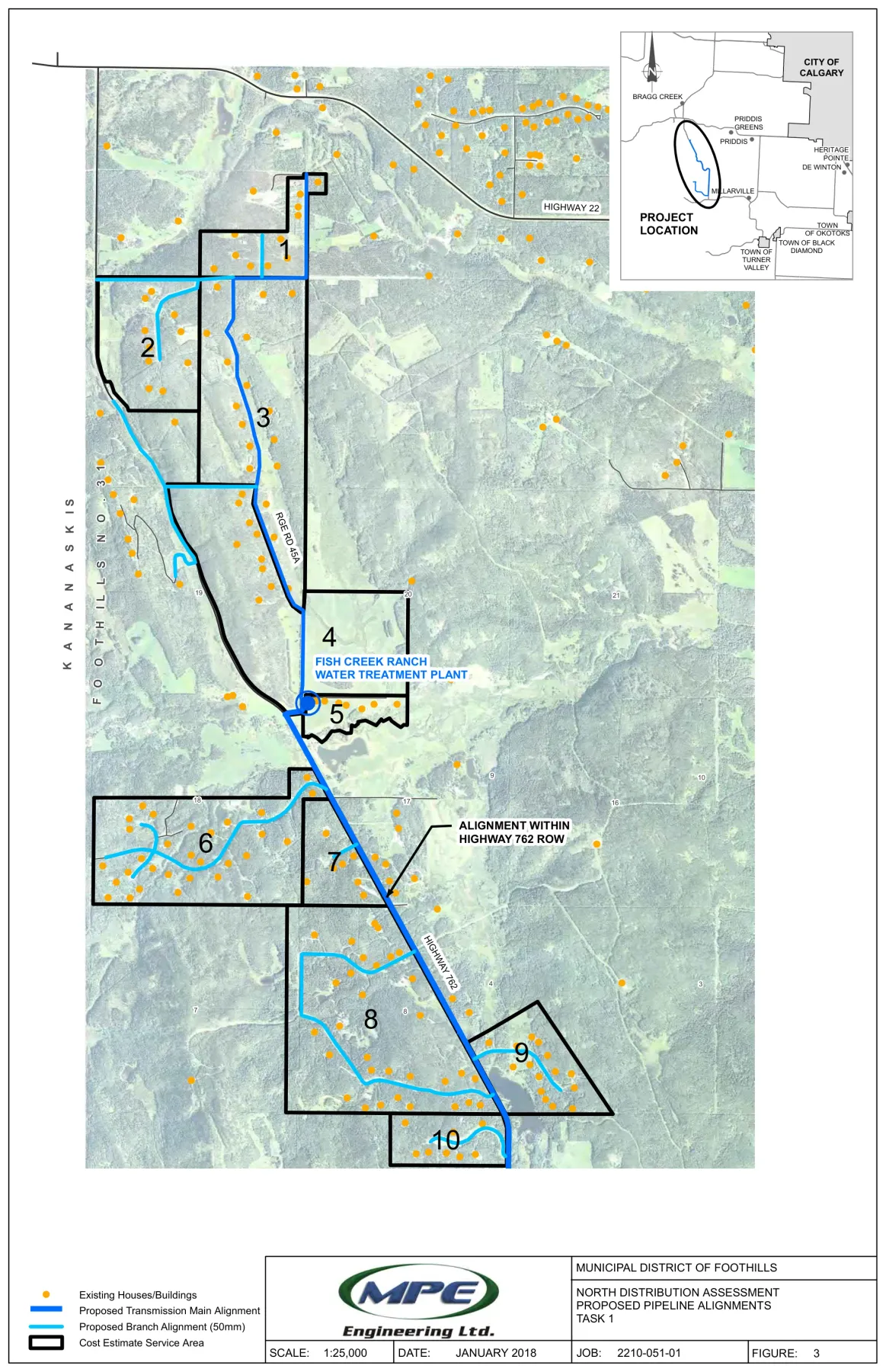
Figure 1 is the Task 1 sheet: the transmission main down Highway 762 and Range Road 45A, with the ten costed service areas outlined.
Phase 1
Task 1 covered Range Road 45A to the north and about 4 km south along Highway 762. It identified 166 lots and costed 159 connections. The transmission main runs roughly 9 km at 100 mm diameter, with 50 mm branch lines inside county rights of way, sized to hold a minimum of 150 kPa, which is 21.8 psi, everywhere on the system [3]. Design flow was 250 m³ a day and the projected yearly demand 62,105 m³, or 50 acre feet [3].
Phases 2 and 3
Figure 2 is the county's own service area sheet, with the household count marked in each of the three.
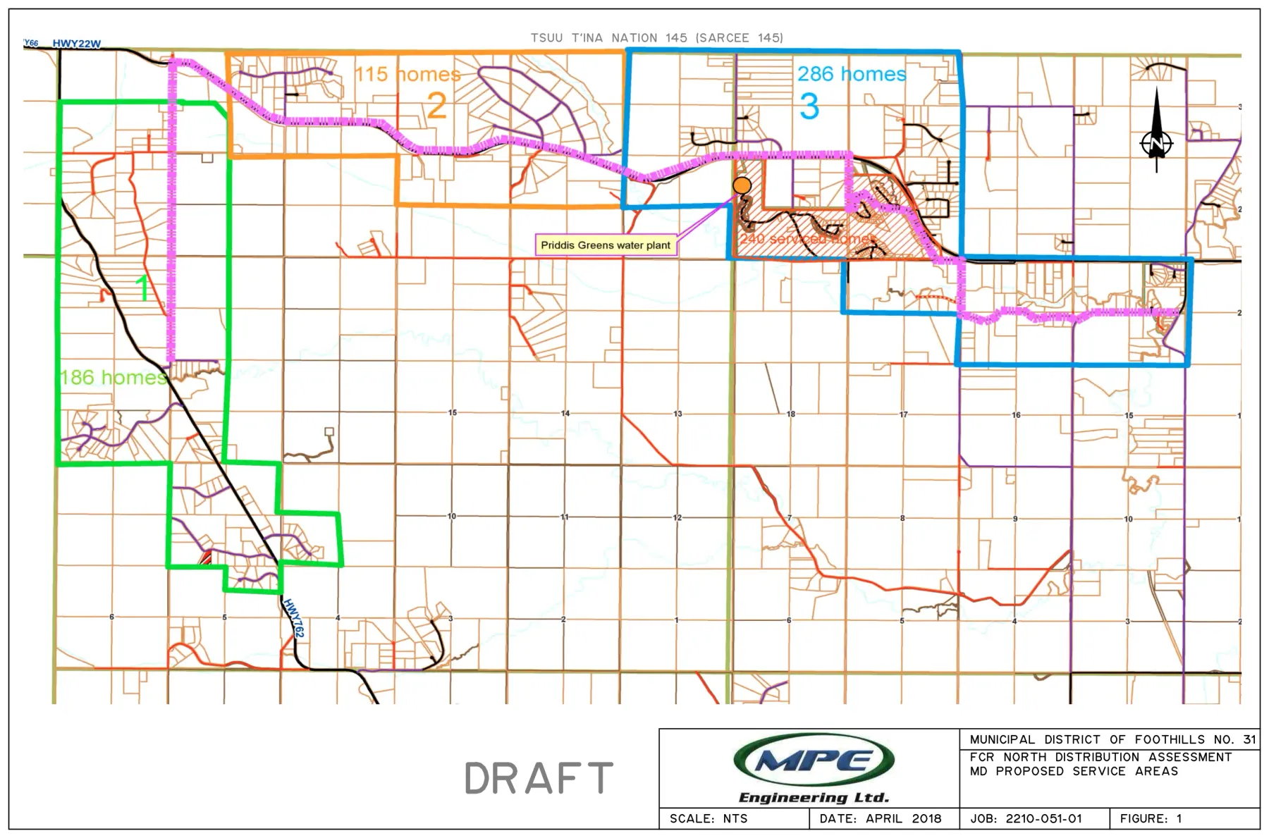
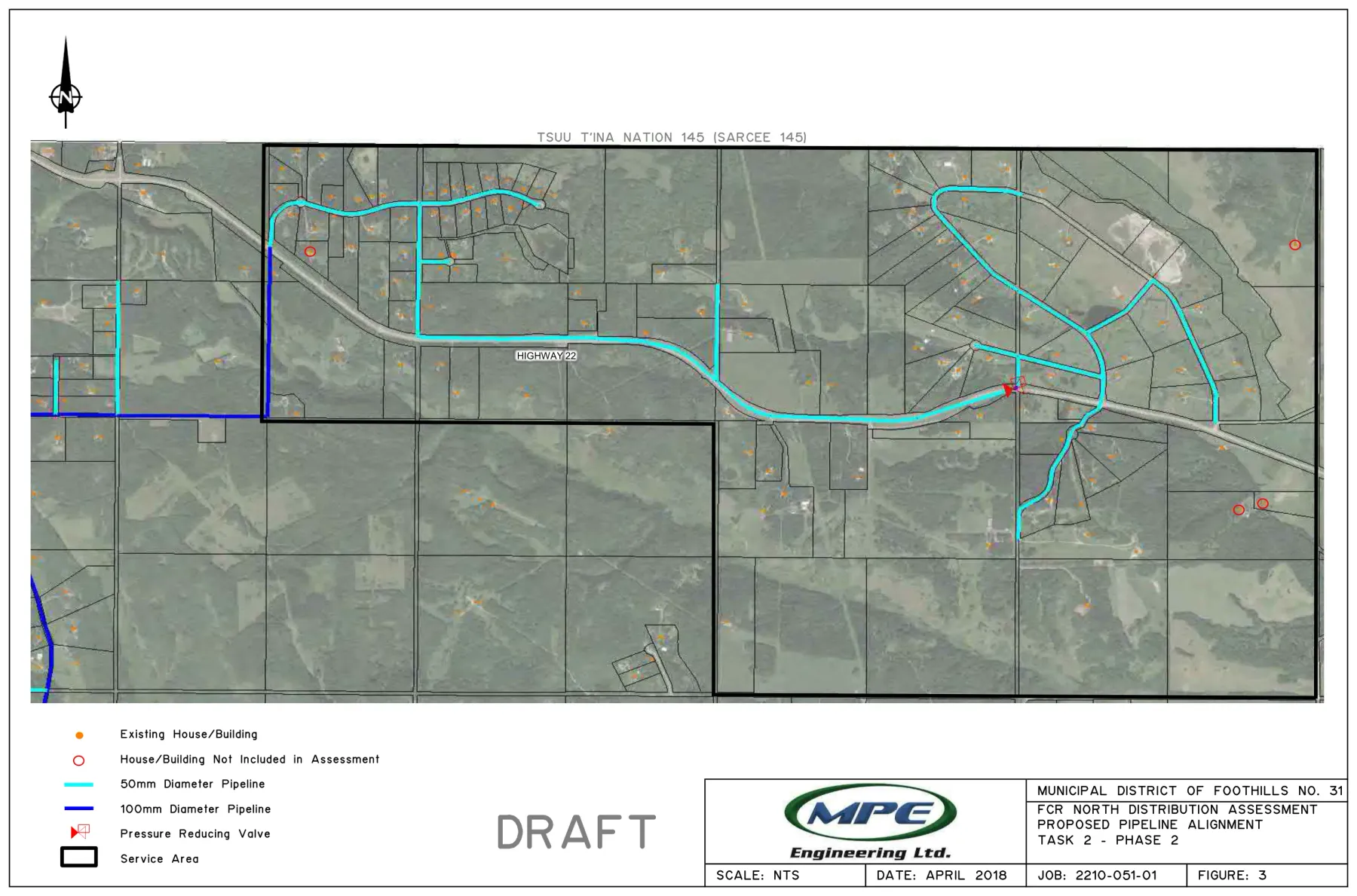
Task 2 extended the system east along Highway 22. Phase 2 runs to Priddis Creek Drive: 2 km of 100 mm pipe from the north end of Phase 1, then 7.6 km at 50 mm. The terrain forces a pressure reducing valve, without which static pressure would reach about 260 psi [4]. The county identified 115 possible connections in Phase 2; 4 of them had no direct access to the alignment, so 111 were costed. The alignment is Figure 3.
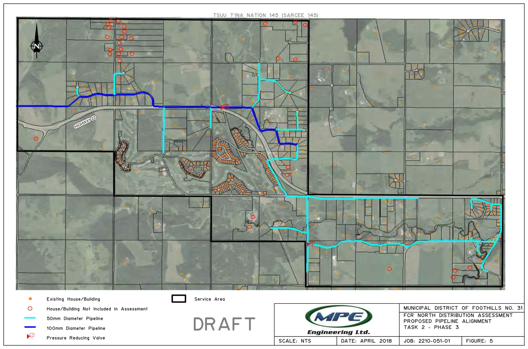
Phase 3 continues east to Priddis Valley Road, at 224 Street West, and takes in the Hamlet of Priddis. The county identified 286 lots there. MPE could locate 264 in the address data, of which 14 were off the alignment and 16 could not hold minimum pressure without a booster station, leaving 234 costed connections [4].
Phase 3 is the one that changes the earlier phases. It carries close to double the demand of Phases 1 and 2 combined, so the Phase 1 main has to be upsized from 100 mm to 150 mm and Phase 2's 7.6 km of 50 mm becomes 100 mm, plus a further 6 km of 100 mm and 9.6 km of 50 mm to carry the main into Priddis, and two more pressure reducing valves [4]. Building Phase 1 without allowing for Phase 3 means digging Phase 1 up again. Figure 4 shows how far east it reaches.
What it came to
Across all three phases the assessment counted 511 lots and a yearly demand of 191,178 m³, which is 155 acre feet, at a design flow of 720 m³ a day. Table 2 is what it was costed at [4].
| Cost estimate | Phase 1 | Phase 2 | Phase 3 |
|---|---|---|---|
| Costed connections | 159 | 111 | 234 |
| Construction | $5,122,000 | $5,368,000 | $7,839,000 |
| Upgrading earlier phases | none | none | $364,000 |
| Additional water licences | $232,500 | $248,000 | $535,000 |
| Grand total | $5,354,500 | $5,616,000 | $8,738,000 |
| Cost per lot | $34,000 | $50,600 | $37,300 |
| Connection fee per lot | $15,000 | $15,000 | $15,000 |
| Total per lot | $49,000 | $65,600 | $52,300 |
Plant upgrade costs are separate again, and are set out on the treatment plant page.
The $15,000 connection fee is not the engineers' invention. It comes from the April 2012 lease agreement between Fish Creek Ranch and the county, which fixes the fee at $25,000 a lot for four named existing lots, nothing for four others, and $15,000 for every other lot in the service area [2].
The assumptions these numbers rest on
The estimates are Class D, which is the coarsest grade an engineer issues: an order of magnitude figure for deciding whether to look further, not a budget. They carry a 25 per cent contingency and assume the following [3] [4].
- Alberta Transportation permits the main inside the highway right of way. The province generally does not allow water and sewer inside its road allowances. MPE recorded that it had been permitted here before, that a business case would be required, and that the report simply assumes approval is granted. This is the largest single assumption in the file.
- Easements are granted where the pipe crosses private land, at an assumed $3,200 an acre in Task 2 and not costed at all in Task 1.
- Additional water licences can be bought at an assumed $7,500 an acre foot, excluding the professional cost of any river study, statement of concern or appeal.
- The whole pipeline can be directionally drilled and the ground cooperates.
- The reservoir has enough capacity, which the engineers themselves flagged for confirmation.
Where this leaves the co-op
Council accepted Phase 1 in principle on 30 May 2018 and Phases 2 and 3 were left subject to a later approval that has not happened [2]. Nothing has been built. The engineering is eight years old, the costs are in 2018 dollars, the alignments were drawn against 2018 address data, and no fire flow was ever included.
That is still a considerable head start. A route exists, a hydraulic model exists, the phases are defined, and the treatment hub is built and running. What the project needs is a current cost estimate, an answer on the water licences, and a decision. It does not need to start from a blank sheet.
Read the documents yourself
Nothing on this page needs to be taken on trust. The North Distribution Assessment has been public since 2021, posted by West Foothills Water, the community site that has followed this file with the Division 4 councillor since long before the co-op existed. Its document list carries, among others:
- MPE Letter Report: North Distribution Assessment
- FCR North Distribution Assessment Report
- FCR North Distribution Report, May 2018
- Updated service area map
- Council meeting minutes, November 2020
Those are that site's own titles and its own links, reproduced without change so you can match them against what it publishes. The water licences are public too, at the province's water licence viewer and in the water allocation data. The one document on this page that is not published anywhere is Associated Engineering's 2018 valuation, which sits in the co-op's records: ask the board and you can read it.
Related: The reservoir and The water treatment plant.
Sources
Associated Engineering Alberta Ltd., Fish Creek Ranch Water Treatment Plant Valuation, report prepared for Fish Creek Ranch (September 2018), secs. 1.1, 1.2, and 3.2. Unpublished; a copy is held in the co-op's records.
Associated Engineering Alberta Ltd., "Strategic Value of Fish Creek Ranch Water Treatment Plant," app. F to Fish Creek Ranch Water Treatment Plant Valuation (September 2018), reproducing the connection fee schedule from the lease agreement of April 16, 2012, and the council recommendation of May 30, 2018.
MPE Engineering Ltd., "Fish Creek Ranch: North Distribution Assessment (Task 1)," letter report prepared for the M.D. of Foothills No. 31, job 2210-051-01 (May 24, 2018), attn. Jeff Edgington, C.E.T., Supervisor of Infrastructure. West Foothills Water, accessed August 8, 2026, https://westfoothillswater.ca/.
MPE Engineering Ltd., "Fish Creek Ranch: North Distribution Assessment (Task 2)," draft letter report prepared for the M.D. of Foothills No. 31, job 2210-051-01 (May 24, 2018), table 5. West Foothills Water, accessed August 8, 2026, https://westfoothillswater.ca/.
Questions about this document: info@fishcreekwater.co
Back to homepage